


Kitsissuarsuit is one of three settlements belonging to Aasiaat and is situated approximately 21 km north of Aasiat, on the southernmost of a group of islands named Kitsissuarsuit. The settlement was founded as a trading station in 1830, and before that, the settlement was used by whalers until 1817.
Provisions and subareas
The general provisions apply to all subareas of the municipalities in towns, settlements and open country areas. The provisions are general and do not consider the local conditions in the subareas.
General provisions of the Town Plan
The overall provisions for each subarea are the basis for the municipality"s granting of area allotments and building permits.
Kitsissuarsuit’s present service and housing level is to be sought maintained or adjusted to the decreasing number of inhabitants. Further town development is to take place within the existing settlement zone. Sufficient industrial areas should be allotted for the potential construction of fish processing plants or skin processing facilities. The inhabitant’s wish to develop the settlement’s tourist potentials should be supported in cooperation with Aasiaat. The settlement’s outdoor areas can be improved by providing lighting and good meeting places.
Population has been steadily declining since 1989 (128) and the settlementnow has 59 inhabitants in 2017. It is expected that the population will continue to decline and that during the plan period there will be a primary need for compensation building in connection with remediation.
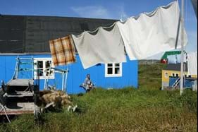
The homes are all detached, 1-1½-storey single-family houses, most of them built after 1975. The town plan leaves room for approximately 60 homes in Kitsissuarsuit.
Existing jobs primarily lie within fishing, sealing and whaling. There are also jobs within the service sector, the shop, the school and the municipal facilities and offices. There is no production plant and only limited trading.
In 1987, the port was extended with a fixed quay in the north-eastern part of the settlement. Dinghies and boats are primarily anchored in the inlet south of the port, which offers hauling facilities. From the fixed quayside and 500 meters to the east, Naalakkersuisut has designated a port authority area.
The three settlements in the Aasiaat district had a total unemployment rate of 10.2 in 2015, which is higher than for Aasiaat (8.2%), but resembles the general picture of the municipality Qeqertalik. This corresponds to the municipal average (10.7%), but slightly higher than the national average (9.1%).
The town plan leaves room for building approximately 2,500 m2 for industry and port purposes
The settlement is serviced by a helistop, situated west of the settlement.
The road structure mainly consists of a thorough wheel track from the port and telecommunications installation in the north to the dump and cemetery in the south.
A diesel-powered power plant was built in 1987 close to the port and water production is based on desalination plants with pipelines and tap houses. Operations are handled by Nukissiorfiit. Housing are heated using independent oil burners. Waste is deposited on the dump south of the settlement along with night soil. The settlement features a church (from 1928), a settlement consultation post, trading of raw materials (B-93 offering packing of dried meat and narwhal blubber), municipal workshop including laundry, a carpenter’s workshop and KNI Pilersuisoq.
The elementary school (Ole Reimerip Atuarfia) numbers around ten pupils.
The trading station manager’s house (B-93), the former (B-159) and the current school buildings (B-875) as well as the three old warehouses (B-86, B-90 and B-91) are designated preservation-worthy.
An area is zoned for a soccer field north of the helistop. The former village hall was included in the educational facilities in 1988.
